
KEY IDEAS:
- Publicly available data — such as weather, population demographics, business locations, court records, and inmate mugshots — often provides critical context for safety agencies.
- Integrating open source datasets with internal agency data can reduce context switching, enhance situational awareness, and build a more comprehensive operating picture.
- Peregrine merges disparate datasets, including open source data, to save time, improve accuracy, and support evidence-based decisions for public safety agencies.
In public safety, analysts and investigators often rely on open source data to answer critical questions about people and places that their agencies’ data cannot answer on its own. However, without an effective integration solution combining their disparate data sources, personnel may find themselves toggling between internal data systems and external public sources to manually piece together insights.
By ingesting open source data and integrating it with customers’ internal data sources, Peregrine turns that tedious, time-consuming, and unreliable workflow into a simple, efficient process.
Keep reading to learn how public safety leaders can best leverage open source data to find fast, reliable answers to their most important questions.
What is open source data in public safety?
Many public and private organizations publish open source data, or data that’s openly available for anyone to access and share, on their websites. State departments of corrections sometimes make inmate mugshots and aliases public; the U.S. Census Bureau makes population, economic, and demographic data free to find, view, and use; and some county clerks of the courts make their records openly accessible.
Internal agency data, by contrast, lives in an agency’s internal information systems and is only accessible and shareable by certain authorized personnel, who must follow security protocols.
Why is open source data valuable for public safety agencies?
Let’s look at a few common applications of open source data in the public safety space.
- Emergency management: Publicly available weather data enables more precise predictions of storm activity.
- Custody operations: Corrections information provides a more comprehensive picture of current and past jail inmates.
- Criminal investigations: Mugshots from open-source inmate databases provide useful identifying information for detectives and investigators.
- Narcotics enforcement and response: Map data helps agencies better understand overdose rates per capita in rural areas.
- Informed resource distribution: Law enforcement leaders can respond more strategically to organized retail theft by understanding which types of businesses are being targeted the most often, and in which areas.
💡 WHAT IS THE ROLE OF OPEN SOURCE DATA IN PUBLIC SAFETY? In the context of public safety, open source data is publicly available information gathered from open sources that personnel can use to generate investigative leads, enhance situational awareness, and detect threats.
How does Peregrine integrate open source data?
“With the same person, there could be 23 different entries, and I could never get the full picture of the who, what, where, and when without going into 23 different cases and reading every report. Peregrine's ability to merge entities and provide a quick, holistic view is huge for us.” —Lindsay Harris, Intelligence Division Commander, Cherokee Sheriff’s Office
Publicly available information can add valuable context and meaning to an agency’s internal data — but only if the agency can find an effective way to integrate those disparate sources. Peregrine streamlines this process by:
- Ingesting agency data and open source data in one collective, intuitive platform
- Applying Match, a proprietary entity resolution algorithm, to deduplicate similar records across all ingested data sources
- Automating advanced analytics workflows to provide instant, accurate insights
Peregrine Match merges duplicate person records across all integrated data sources — including both internal and public data — to create a single, comprehensive record for each individual who appears in those sources.
For example, the Cherokee Sheriff’s Office (CSO) uses Peregrine to integrate open source data from the Georgia Department of Corrections (GDC) with the CSO’s own data sources. Match saves time and reduces context switching for personnel who use internal and GDC data to understand inmates at the county jail.
“With the same person, there could be 23 different entries, and I could never get the full picture of the who, what, where, and when without going into 23 different cases and reading every report,” said CSO Intelligence Division Commander Lindsay Harris. “Peregrine's ability to merge entities and provide a quick, holistic view is huge for us.”
💡 WHAT IS ENTITY RESOLUTION? In the context of data management, entity resolution refers to the process of identifying and linking various records referring to the same real-world entity or person across multiple data sources.
What are real-world use cases for open source data in Peregrine?
Below we explore several real-world examples of how our customers can leverage open data in Peregrine. Note that this isn’t an exhaustive list — our team is always finding new public sources and ingesting additional data to build richer context and faster workflows for our partner agencies.
How can mugshots help investigators identify suspects?
Source: Inmate data from the Georgia Department of Corrections
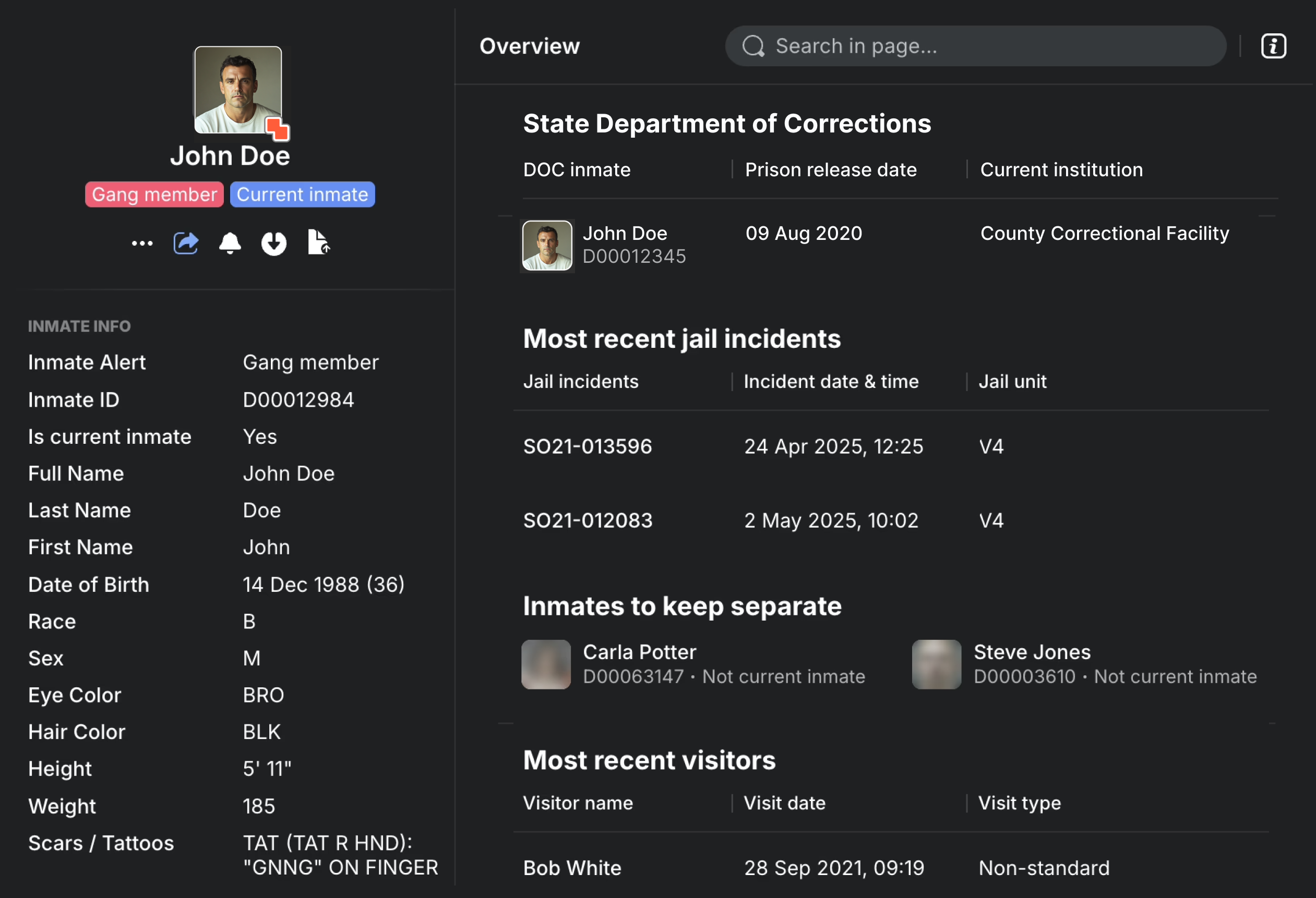
The above image contains notional data.
Peregrine worked closely with GDC to ingest state corrections data and integrate it with the CSO’s records management system (RMS), jail management system, and jail visitation system. Rather than manually scrolling through mugshots on GDC’s website, CSO personnel can now securely access GDC data in bulk and search against all integrated sources on one unified platform.
GDC data in Peregrine helped Harris identify an individual who had provided false contact information when signing in for a video visit with a Cherokee County Jail inmate. Harris had only two pieces of valid information to work with: a residential address — which was a real address, but not the visitor’s home — and video footage from the virtual visit.
Harris searched the address in Peregrine to find information about the home’s residents and any other individuals associated with them. One of the residents’ associates popped up with a GDC mugshot attached — it was the mystery visitor.
"I was able to affirmatively identify the individual simply by glancing at a photo within a large list of possible associates in Peregrine," Harris said.
By integrating state corrections data, Peregrine enabled Harris to identify the visitor in a matter of minutes. Otherwise, she said, she may have never been able to do it.
"The amount of time Peregrine saved me by connecting the individuals and providing a photo from an outside agency is invaluable,” Harris said.
READ MORE → Cherokee Sheriff’s Office: Integrated Jail Management for Data-Driven Decisions
How can open place data prevent organized retail theft?
Source: Place data from Meta and Microsoft
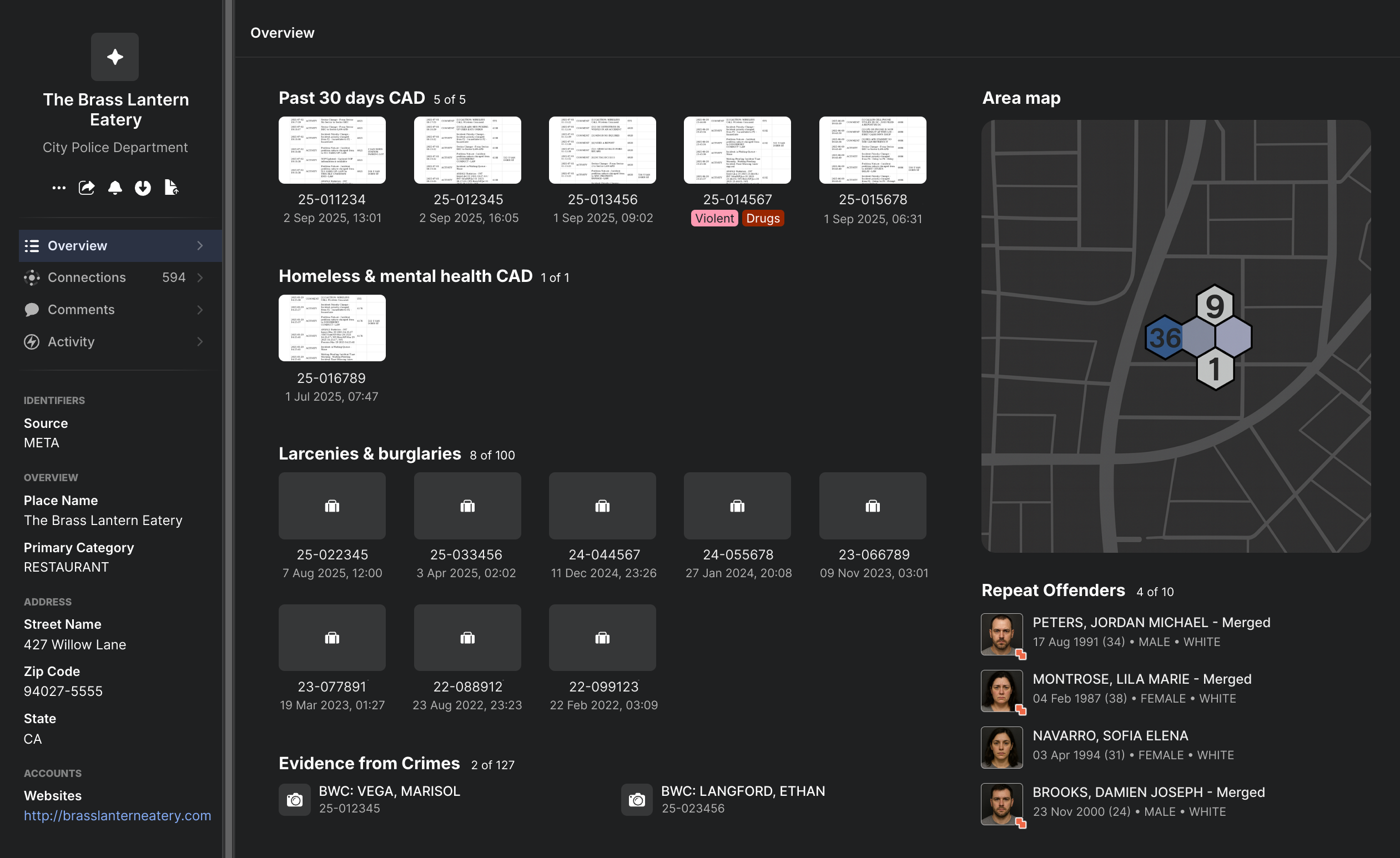
The above image contains notional data.
When a theft takes place at a business, the responding law enforcement agency’s RMS and computer-aided dispatch (CAD) systems will record the address where the crime happened, but not always the name of the business associated with that address. This makes it difficult to identify how crime trends relate to specific businesses.
Because some private software companies make their place data openly available, Peregrine is able to ingest that information and tie the addresses in RMS and CAD systems to corresponding business names based on location. Agencies can then use Peregrine to answer questions such as:
- Which gas stations are being targeted for theft the most often?
- Which businesses have seen more than five larceny events in the last two weeks?
- Which retailers are at the highest risk of petty theft?
- What is the incident history for this particular business?
The Fairfax County Police Department (FCPD) uses Peregrine to identify spikes in larceny, including high-risk retailers that may need more police support. Major Hudson Bull said that when he notices a spike in larceny in FCPD’s jurisdiction, Peregrine can quickly show him which retailers are being hit the hardest.
“It helps us identify where we need to move resources or ship some of our technology that we could use to help those cases,” he said. In some cases, FCPD even reaches out to high-risk businesses to discuss camera sharing agreements for increased prevention.
READ MORE → Fairfax County Police Department: Child Abduction Suspect IDed in 13 Minutes
How can public weather data improve emergency response?
Source: Radar, river gauge, rainfall, and other hydrology data from the National Weather Service
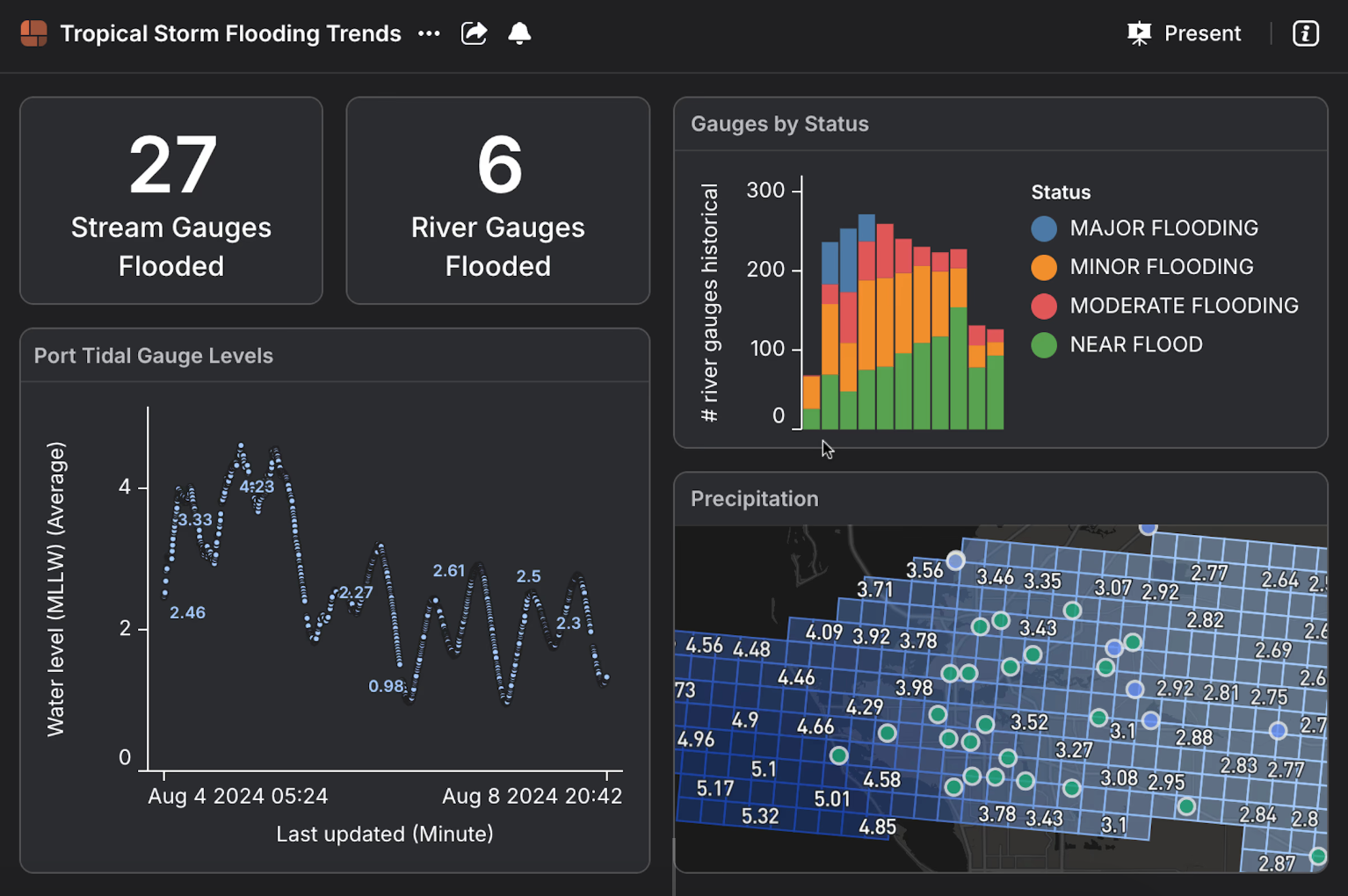
The above image contains notional data.
To gauge the threat of flooding during a hurricane or major storm, emergency managers must monitor the water levels at each individual river and creek in their jurisdiction. The National Weather Service (NWS) makes real-time water level information publicly available on its website — but it does not provide a way for users to monitor multiple rivers and creeks at the same time.
Historically, when hurricanes moved through the Tampa Bay area, Manatee County Director of Public Safety Jodie Fiske said her emergency management personnel would have “easily 20 tabs open” monitoring local river gauges on the NWS’s website.
“We would have had to individually click through each tab to see each individual river or each individual creek,” Fiske said. “That is very cumbersome. We do not have time to do that.”
But when Manatee County onboarded Peregrine in 2024, that changed. Peregrine now integrates live water level data from the NWS and displays it on a map that updates in real time. This gives emergency managers a complete, up-to-date understanding of the flood risk during a storm so they can make more informed decisions to mitigate damage.
“I can see all of [the water levels] at once, and I can say it’s not just a ‘reasonable assumption,’” Fiske said. “It is a fact that this is what our situational picture is looking like.”
READ MORE → Manatee County Sets a New Standard for Hurricane Response
How can census data help agencies understand overdose rates per capita?
Source: Population data from the U.S. Census Bureau
A heat map of overdoses can tell you where the most overdoses are happening, but not which areas are seeing the most overdoses per capita. So for agencies looking to serve hard-hit rural areas — which may have low population density but disproportionately high overdose rates — a simple heat map won’t cut it.
The U.S. Census Bureau collects and reports data across census tracts, which divide county jurisdictions according to population density, with each tract averaging around 4,000 people. Because census tracts are population-equalized, they can help illustrate per-capita trends.
A state-level investigative agency partnered with Peregrine to help inform resource allocation for its NARCAN distribution program. Peregrine integrated agency data on overdoses and NARCAN deliveries with open source census tract data to adjust for population density. The resulting map illustrated overdose and distribution rates per capita across the state, highlighting service gaps in sparsely populated areas.
How can open court data support investigations?
Source: Case data from the clerk of courts in a large Florida county
A county clerk of the court handles proceedings and records for traffic violations and criminal and civil cases in their jurisdiction. Clerk of courts data typically includes case numbers; defense attorney and judge names; bond amounts, types, and issue dates; arresting agency names; arrest and hearings dates; and details on charges. Some counties make this information publicly available; law enforcement agencies can then use it to better understand a person’s history or even track an offender who has an upcoming court date.
In one major county in Florida, data from the clerk of courts is free to access; however, it’s also difficult to navigate without a third-party integration solution because the databases require users to search using precise information. So if a user inputs a misspelled name or an outdated address, they might not find the records they need.
To ensure a simpler, more effective search experience and reduce overall context switching, a local police department uses Peregrine to integrate internal agency data with county clerk of courts data. Now, detectives and analysts can search a name in Peregrine and gain an instant, comprehensive understanding of that person’s situation, including whether they’ve missed past court dates or have any coming up in the future.
Discover how open source data can support your agency
Open data access isn’t always enough — you must be able to find and navigate the data you need and understand the information in context. An advanced integration and analytics solution like Peregrine can integrate public databases with your agency’s internal sources to streamline and enhance analyses and investigations.
Peregrine is always adding to its library of open data sources, and we listen to our community. If your agency uses an open source or publicly available data system that you’d like to see in Peregrine — or if you want to learn more about our open source integrations and workflows — contact our team.


 Your Privacy Choices