KEY IDEAS:
- Manatee County’s emergency operations center (EOC) relied on dozens of disconnected data feeds during storms, delaying access to critical information and limiting real-time visibility.
- These gaps forced emergency managers to act on incomplete or outdated information, slowing decision making during time-sensitive hurricane response efforts.
- By integrating real-time and historical data into a single platform, Manatee County created a unified operational view across the emergency response lifecycle.
- With unified data, the EOC improved situational awareness; strengthened resource requests; enhanced communication; and enabled more effective evacuation, search and rescue, and recovery efforts.
"This technology is not just a huge benefit to us. It’s a benefit to our residents, because the faster we’re able to do our jobs, the faster we can get them assistance.”
Jodie Fiske, Director of Public Safety
Manatee County, Florida

MANATEE COUNTY, Fla. — Since August 2024, three major hurricanes — Debby, Helene, and Milton — have caused more than $750 million in property damages throughout Manatee County, Florida. With recent years bringing more frequent and severe natural disasters to the area, county officials have faced growing pressure to innovate their emergency management strategies.
In August, Manatee County Emergency Management stepped up to that challenge. Just days before Hurricane Debby made landfall in Florida, Manatee County finalized an investment in Peregrine’s data integration technology.
Manatee County Chief of Emergency Management Matthew Myers said Peregrine demonstrated immediate value during the Debby activation by improving situational awareness and providing unprecedented access to historical data. This has empowered Manatee County to level-up its approach across the emergency management lifecycle.
“That is going to help us tremendously in our planning, our processing, and in future mitigation, tenfold,” Myers said. “It’s fantastic.”
By unifying real-time and historical data into a single platform, Manatee County improved real-time visibility, accelerated decision making, and increased response effectiveness across the emergency management lifecycle.
🔎 WHAT IS DATA INTEGRATION IN EMERGENCY MANAGEMENT? Data integration connects multiple systems into a unified platform, enabling real-time visibility, analysis, and coordinated response during emergencies.
How fragmented data delays critical information during emergencies
During storm activations, Manatee County’s emergency operations center (EOC) personnel once relied on live feeds from dozens of disparate sources to gain insights into the events unfolding outside the EOC’s walls.
🧠 WHAT IS AN EOC? An EOC, or emergency operations center, is a central facility where personnel:
- Monitor real-time conditions
- Coordinate strategic responses
- Communicate with stakeholders
- Manage and deploy resources
EOCs may be activated during a natural disaster, public safety threat, or other emergency incident.
Before Peregrine, to gain real-time situational awareness during a storm activation, EOC personnel had to manually switch between siloed systems to access critical information including:
- Precipitation data
- Weather forecasts
- Water gauge data
- Lift station metrics
- CAD data
- Incident management resources
- Shelter occupancy
- Road closures and evacuation routes
- Power outages
However, that method provided only a partial snapshot since personnel were unable to view all of the live data at once or access logs of that data later on.
As a result, emergency managers lacked a complete, real-time understanding of evolving conditions. Without a unified platform that provides dynamic insights into developing events, EOC personnel risk acting on stale information. They must rely on instinct and guesswork, rather than data-driven responses.
🔎 WHY IS FRAGMENTED DATA A CHALLENGE DURING EMERGENCY RESPONSE? Fragmented data forces emergency teams to rely on multiple disconnected systems, slowing down decision making and limiting real-time visibility during time-sensitive events like hurricanes.
How Manatee County unified emergency data to improve real-time response
“In the future, the technology that integrates all of these systems is going to be a necessary tool, not just a great tool to have," —Matthew Myers, Chief of Emergency Management, Manatee County
To move from fragmented, siloed data to a unified operational picture, Manatee County turned to data integration. Manatee onboarded Peregrine while the county was bracing for Hurricane Debby’s imminent impact. To beat the incoming storm, Peregrine’s team rapidly deployed onsite to integrate data from Manatee County’s most critical emergency management sources in a unified platform.
💡 HOW IT WORKS:
- Peregrine integrates historical data and real-time information from multiple emergency systems into a single platform.
- Automated analysis, configurable alerts, dynamic visualizations, and interactive maps enhance decision making.
- Emergency managers can monitor, analyze, and act on all critical data from a unified platform in real time.
As a result, EOC personnel could monitor live data via a collection of comprehensive dashboards and maps. They could also access historical logs of that data later on. This allowed EOC personnel to shift from manual data gathering to real-time analysis and decision making.
“In the future, the technology that integrates all of these systems is going to be a necessary tool, not just a great tool to have," Myers said.
Peregrine brought all of Manatee County’s disconnected data sources into a unified view, providing immediate access to meaningful, actionable insights without manual analysis. As a result, EOC personnel could allocate more time to high-impact work as they prepared, responded, and recovered from Hurricane Debby.
🔑 KEY TAKEAWAY: Unified data provides real-time visibility across systems, enabling faster, more accurate decision making throughout the emergency response lifecycle.
READ MORE → How Data Integration Helps 4 Florida Agencies Protect 2.5 Million Residents
How unified data enables confident resource requests
“The faster we have this information, the faster we’re able to substantiate our damages, the faster that money goes to our residents who need the help." — Jodie Fiske, Director of Public Safety, Manatee County
Asking for state or federal resources requires confidence. With a hurricane approaching, county officials might request state resources to deploy a flood barrier in an area that’s vulnerable to flood damage. But they should make sure they can back up that request, because as Manatee County Director of Public Safety Jodie Fiske explained, a flood barrier is no small ask.
“That’s a multi-million-dollar resource,” she said. “That is not an easy resource to deploy. It requires the National Guard to come with it. It is a day of setup.”
But what happens if officials overestimate a flood risk and request a multi-million-dollar deployment that turns out to be unnecessary? Fiske said they may end up wasting resources or even taking them away from higher-need areas.
“Those resources could have been sent someplace else,” Fiske said. “Not to say they didn’t get there, but they could have gotten there faster.”
For Manatee County, Peregrine provided a more complete operational picture so the county could request resources with confidence ahead of Helene and Milton.
🔎 HOW DOES REAL-TIME DATA IMPROVE EMERGENCY RESOURCE ALLOCATION? Real-time data provides a complete operational picture, allowing officials to identify needs, justify resource requests, and prioritize high-risk areas more effectively.
“We have phone calls with the state twice a day during an activation,” Fiske explained. “We were really able to present a full operational picture of what was happening in the county and what our needs were.”
With immediate access to reliable data, Manatee County’s emergency managers can more accurately identify resource needs and request state assistance during activations.
🔑 KEY TAKEAWAY: Unified data gives emergency managers a complete operational picture, enabling more confident and accurate resource requests.
The above image contains notional data.
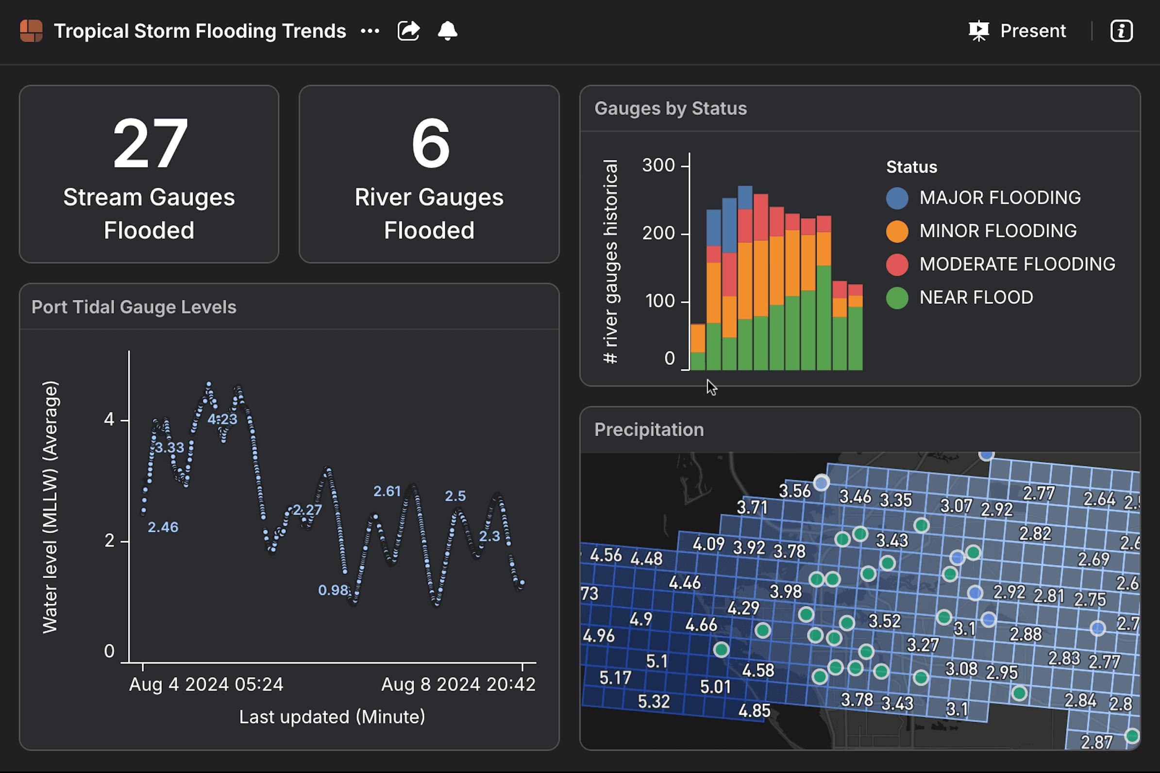
How unified data improves storm preparation and situational awareness
Unified data improves storm preparation by providing a complete, real-time and historical view of conditions across the county. To fully understand the flood threat during a storm, emergency managers must know what’s happening with each individual river and creek in their jurisdiction. Before Peregrine, Manatee County had no reasonable way to get that information.
“We would have had to go to the National Weather Service (NWS), and we would have had easily 20 tabs open on a computer, and we would have had to individually click through each tab to see each individual river or each individual creek,” Fiske said. “That is very cumbersome. We do not have time to do that.”
To save time, the EOC would make “reasonable assumptions” about flood risk based on a small sample size of two or three rivers or creeks, Fiske explained. But Peregrine provided better situational awareness so emergency managers could make more informed decisions to mitigate flooding.
“I can see all of them at once, and I can say it’s not just a reasonable assumption,” Fiske said. “It is a fact that this is what our situational picture is looking like.”
🔎 HOW DOES UNIFIED DATA ENHANCE EMERGENCY PREPAREDNESS?
- Increases situational awareness
- Streamlines real-time communication
- Improves access to historical data
- Informs resource allocation
- Supports effective evacuation strategies
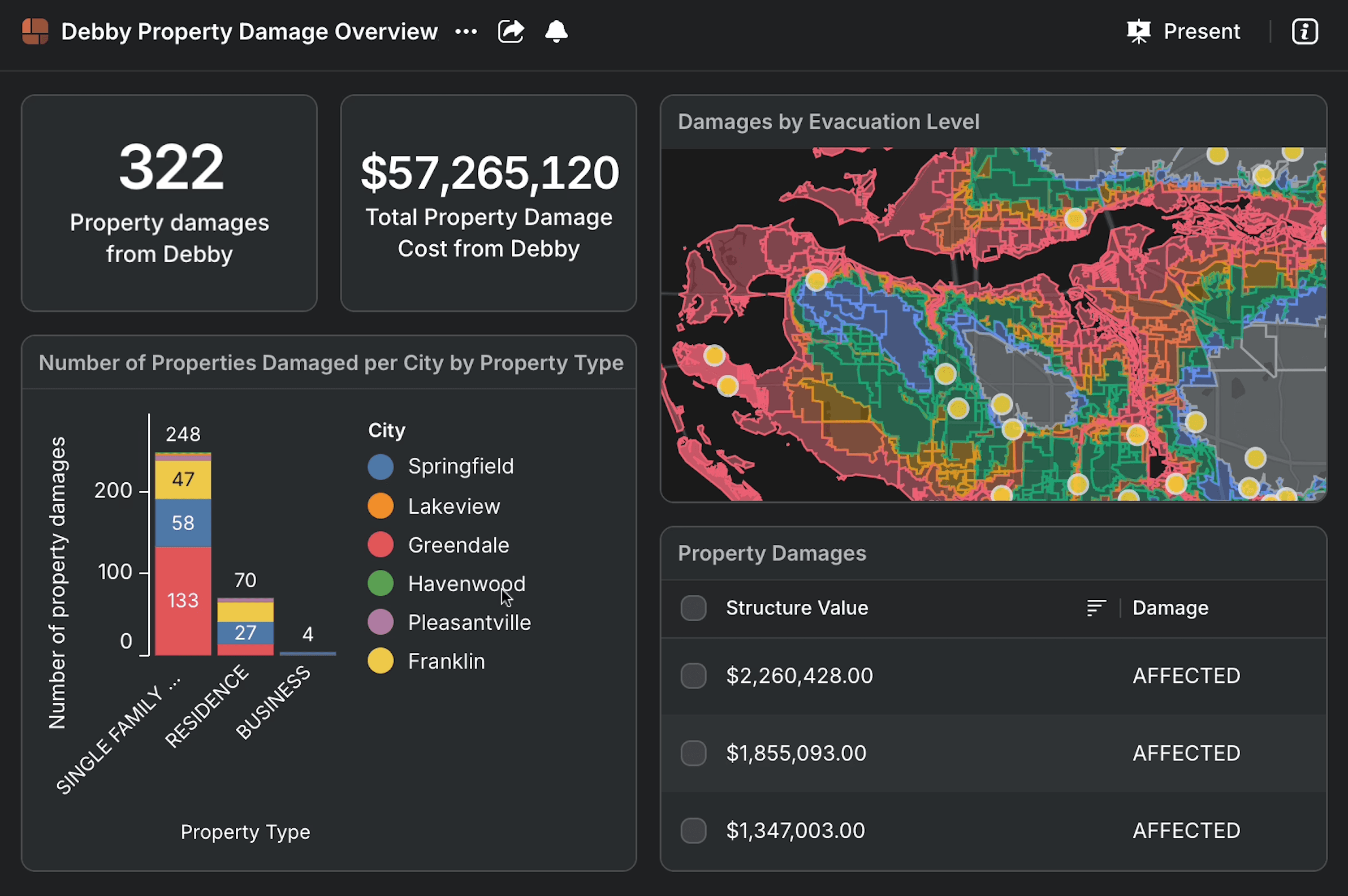
Streamlining real-time communication
That improved situational awareness has also streamlined communications with county commissioners during emergencies. Previously, Fiske said a dedicated team would have to manually calculate damages by district for commissioner briefings. Now, the agency can simply refer to a map in Peregrine that outlines damage costs across each district, broken down by residential, commercial, and county infrastructure.
"We’re able to get them information that is accurate in real time in one place, and they’re good,” Fiske said. "It doesn’t require 10 briefings ahead of time to try to get all the information put together.”
READ MORE → Unlocking the Benefits of Integrated, Real-Time Emergency Management Solutions
The above image contains notional data.
Enabling data-driven protective measures
Accurate, holistic situational awareness enables more effective storm preparation, especially when paired with historical data.
Before Peregrine, Manatee’s emergency managers could only access live situational snapshots from sources like NWS and the National Oceanic and Atmospheric Administration. They couldn’t compare that real-time data with historical logs from past storms to help shape response initiatives. But with Peregrine, emergency managers gained access to reliable historical logs, enabling them to make more data-informed decisions during activations.
When preparing for Helene and Milton, Manatee’s EOC officials could review trends from previous storms to determine which protective measures and resources would likely be necessary and when.
“We can see where the river was for Debby, and it’s the same level that it’s at for this incoming storm,” Fiske said. “Okay, let’s go ahead and let’s put Tiger Dam up to see if we can’t mitigate that extra three-foot rise that we saw during Debby. So being able to get that kind of data helps us with our storm preparation.”
🔑 KEY TAKEAWAY: Combining real-time and historical data enables more accurate forecasting, improving preparedness and mitigation decisions.
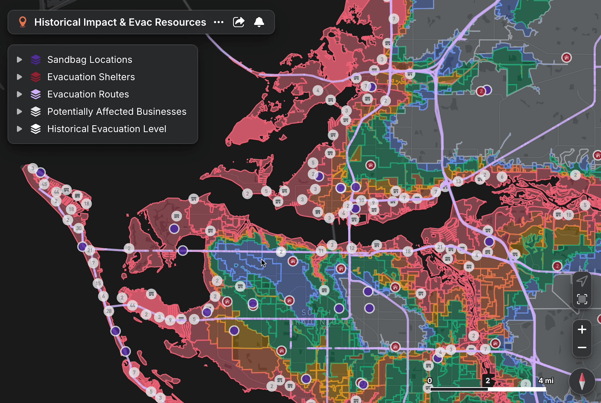
Improving evacuation strategy with real-time data
Fiske put it simply: “The sad fact is, people don’t always evacuate when you want them to evacuate.” But it can be difficult to measure the efficacy of evacuation warnings and orders, especially in the middle of an activation.
Previously, Manatee County’s emergency managers had to manually update their shelter capacity dashboards to visualize the status of each evacuation center during a storm. Now, Peregrine monitors the EOC’s web-based system and automatically updates the shelter dashboards to reflect the latest capacity data. Having real-time shelter data helps emergency managers understand how many residents have evacuated.
“I’m not guesstimating that I’ve got a couple hundred thousand people in shelters,” Fiske said. “I can say with confidence that I’ve got a couple hundred thousand people that evacuated in advance of the storm.”
🔎 HOW DOES REAL-TIME DATA IMPROVE EVACUATION PLANNING? Real-time information and historical data help EOC personnel track evacuation trends, monitor shelter capacity, and adjust messaging to improve outcomes.
In the longer term, emergency managers can review historical evacuation data in Peregrine to identify patterns and understand how to adjust their messaging to ensure more effective evacuations in the future.
“We can look at that historical data and see what the trend was, see where was that peak when people were evacuating, where was the peak when landfall was happening,” Fiske said. “We can adjust our messaging to that, and that wasn’t something we had before.”
🔑 KEY TAKEAWAY: Real-time and historical data enable more effective evacuation strategies by improving visibility into shelter capacity and evacuation trends.
The above image contains notional data.
How real-time data improves search and rescue operations
In addition to planning and resource allocation, real-time data also improved how emergency teams operate in the field. Traditionally, when a resident calls 911 during an emergency activation:
- The 911 dispatch center routes those calls to the emergency services desk.
- That information is then relayed to the urban search and rescue (USAR) teams.
That manual process means EOC personnel lack a real-time understanding of current conditions and priorities. This creates delays and limits visibility into where help is needed most.
But with CAD data integrated into the emergency management department’s system, Manatee County’s EOC will be able to plot those 911 calls in real time without needing emergency services to act as a middleman.
“That takes the burden off of the emergency services branch,” Fiske said. “They’re able to focus more on what their deployment is going to look like after the storm.”
READ MORE → Cutting-Edge Tech For Modern Emergency Operations Teams
Integrating CAD data for emergency activations will also show emergency managers where residents have not evacuated and will require wellness checks. If a cluster of 911 calls comes from the same area, the EOC will know to prioritize that area when sending out urban search and rescue (USAR) teams.
“For the USAR teams, when they’re deployed out, as soon as it’s safe for them to get up in the air and get on the ground, we’re able to direct them now to say these are the areas that you need to hit first, because we know that we had contact from a resident a lot of times,” Fiske said.
💡 HOW DID UNIFIED DATA TRANSFORM EMERGENCY RESPONSE IN MANATEE COUNTY?
- Increased real-time visibility → fast, accurate resource requests to mitigate damage
- Streamlined communication and data access → enhanced preparedness and resource allocation
- Integrated CAD data → real-time 911 call mapping to bolster search and rescue efforts
How real-time data accelerates storm recovery and funding
After the storm, the same real-time data capabilities also accelerated recovery and funding efforts. To secure resources for hurricane recovery, municipal governments must gather and report large amounts of damage data as quickly as possible. To do this, damage assessment teams go into the field as soon as it’s safe after a storm to inspect affected areas, evaluate and document damages, and determine overall impact.
"The faster we have this information, the faster we’re able to substantiate our damages, the faster that money goes to our residents who need the help,” Fiske said.
She explained that Peregrine revolutionized this process for Manatee County by allowing the emergency management team to send data directly from Peregrine rather than having to manually compile it.
READ MORE → Bridging the Gap: Enhancing Disaster Recovery Collaboration Through Data Integration
“You literally are talking about days being saved by having this information,” Fiske said.
Matthew Myers added that because the county could assess damages faster, it secured major disaster declaration status faster, which meant receiving recovery funds faster.
“In Milton, we were declared probably the fastest we’ve ever been declared since I’ve been working here, for eight years,” Myers said.
As a result, Fiske added, the county received expedited reimbursement for debris removal following both Hurricane Helene and Hurricane Milton.
“This technology is not just a huge benefit to us; it’s a benefit to our residents,” she said. “The faster we’re able to do our jobs, the faster we can get them assistance.”
🔑 KEY TAKEAWAY: With real-time and historical data at their fingertips, emergency management officials can complete damage assessments and secure recovery funds faster.
By integrating real-time and historical data, Manatee County’s emergency operations center improved preparedness, accelerated response, and reduced recovery timelines during major hurricane events. Download our latest white paper to learn how investing in integrated emergency management can help safeguard your community.


 Your Privacy Choices